


LARGE parts of Ireland look set to be issued with a Status Orange weather warning ahead of the arrival of Storm Diana on Wednesday.
In a statement, Met Éireann said an upgraded warning was likely after the forecaster updated one of two Status Yellow weather alerts it issued across 16 Irish counties yesterday.
A spokesperson for Ireland's national forecaster said: "At the moment we are experience severe weather, with severe winds and heavy rain. There is a risk of flooding for many areas.
"That will clear slightly this evening but there will be more unsettled weather overnight with more warnings likely to be issued.
"A Status Orange weather warning is likely to be issued as more disturbed weather is expected for Wednesday.
Highest temperatures 8 to 12 degrees. More rain and strong winds will reach the southwest during the evening.
— Met Éireann (@MetEireann) 27 November 2018
"Storm Diana will make its way towards the west and that will certainly beef up the rain. Diana will increase the wind speeds and heavy rain in the west."
On Monday morning, a Status Yellow wind alert was issued to Munster, Dublin, Carlow, Kilkenny, Wexford, Wicklow, Galway and Mayo – but this has now been revised with even stronger gales expected.
Met Éireann added: "Update. Southeasterly winds will strengthen tonight and during Tuesday morning. Mean speeds of 55-65 km/h with gusts from 90-110 km/h expected. Winds strongest along exposed coasts, where a few higher gusts are possible."
The weather warning is in force until 3pm this afternoon, while Storm Diana is set to bring even more gales from Wednesday.
There is also a Status Yellow rain warning in place for the same 16 counties until 2pm today.
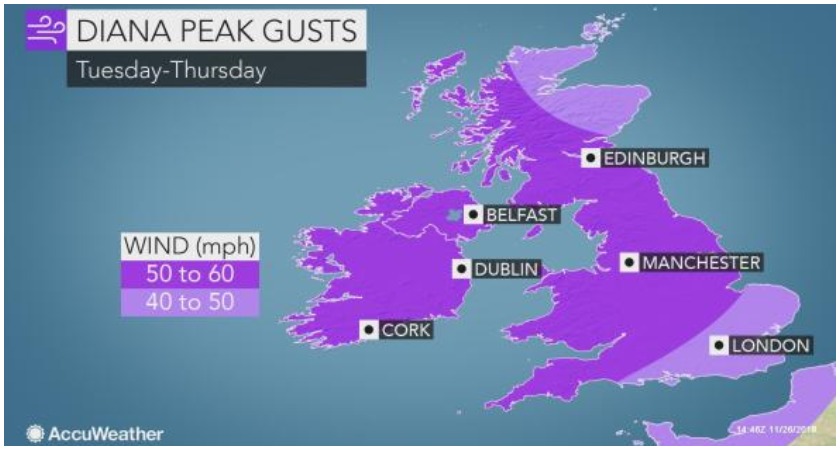
Diana, named by the IPMA Portuguese weather service, will also bring local flooding to some areas of Ireland tomorrow, as well as northern parts of the UK.
Powerful winds topping 85 km/h will blast all of Ireland as well as Scotland, Wales, southeast England and northern England during the day on Wednesday.
Ireland and Northern Ireland will likely suffer the most significant delays to travel during the morning commute, before winds push east during the daytime hours.
The Thursday morning commute in both Ireland and large parts of the UK could also see significant delays caused by the unsettled conditions.
Tuesday
As for today, Met Éireann's outlook is: "Overcast wet and very blustery this morning with heavy spells of rain, gales and severe gusts. The rain will be heavy giving downpours with the chance of flooding locally, but brighter weather with showers will follow gradually from the southwest.
"Southeast gales will ease. Highest temperatures 8 to 12 degrees. More rain and strong winds will reach the southwest during the evening".
As for later: "Tonight will be overcast and windy again. The north and east will begin dry, but rain elsewhere will quickly spread countrywide along with low cloud and mist. Southerly winds will increase very strong with gale gusts. Minimum temperatures 4 to 8 degrees."
Wednesday onwards
And as for the remainder of this week: "Wednesday will be a wet and windy day. Rain will clear the west in the evening and will be heavy at times in the north and northwest. Temperatures will be 12 or 13 degrees in the afternoon and 5 to 7 degrees on Wednesday night. The strong southerly winds will veer southwesterly later.
"Thursday will be drier but there'll still be showers around, mainly on southern coasts, turning to more persistent spells of rain at times in the west and north. Moderate southerly winds will become strong southwesterly.
"Friday will see further showers with strong southwesterly winds gradually easing to a moderate southerly and the further outlook to the weekend indicates continued unsettled conditions with rain at times."
