

THEY call it the Wild Atlantic Way, but that doesn’t quite cut it, TBH.
It’s not just wild; between you and me it can be downright mutinous. It’s the west of Ireland after all, and the Atlantic has had about 3,000 miles to pick up speed.
Of the route’s 1,600 miles of coastal meanderings, the stretch between Kerry and Cork is one of the most spectacular.
Travelling southwards and starting at the top end, in County Kerry, you’ll find yourself at Dingle, An Daingean Uí Chúis, a perfect base from which to explore this startling landscape.
Of course, as you and me know (both of us being seasoned travellers), there are a few negatives. Paddywhackeray is not in short supply throughout the area — there are shops here selling tat so tasteless they’d make a garden-gnome salesman blush.
But Dingle is no mere stage set, or dedicated to commercialism. The fishermen still fish, the musicians still play at the traditional seisiúns at O’Flaherty’s or Foxy John’s, and the local farmers still try to cut a good deal at Dingle Mart.
The road west of Dingle, the Slea Head Drive, clings to the edge of Europe. Every corner presents another Instagram view — Blasket Islands brooding offshore, stone cottages clinging to hillsides, boreens bleeding with fuchsia and lined with that wandering gypsy of a plant, the orange montbretia.
Inch Strand and the Kingdom’s theatre
A FEW miles east, the glorious sands of Inch Strand stretch towards the horizon. This is where Ryan’s Daughter was filmed in 1970, when David Lean spent a year battling the weather and the locals’ scepticism. The same weather that drove Lean to distraction still shapes the skies above Kerry today. For more elucidation on the topic of Ryan’s Daughter, Maurice Galway of Dingle Film Walks will provide you with all the information you might need. https://dinglefilmwalks.com/
Oddly enough, Inch Strand in Co. Kerry was not to Lean’s liking to begin with.
But filming eventually got underway, although matters did not go smoothly. The behind-the-scenes shenanigans would have made for a more gripping production than the actual movie.
Ryan’s Daughter spelled the end of one promising actor’s career, it almost caused the drowning of another, while yet another gave up the profession for several years, so great was the depression that settled on him after the filming. It created lasting animosity amongst the cast, but at least the blockbuster put Inch Strand firmly on the tourist map. That was despite some of the scenes being filmed many miles away — on Noordhoek Beach, South Africa.
Due to poor weather, many of the beach scenes were filmed at Arniston in South Africa, easily identified by the nearby beach’s white sand. The shipwreck where Doryan detonates the explosives is that of the Kakapo, which can be found just south of Cape Town.
(Your date with Dingle Film Walks will not include a journey to South Africa.)
Anyway, you’ll get all the gen on your walking tour.
 The Beara Peninsula straddles counties Kerry and Cork (Pic: Tourism Ireland)
Killarney and the sights of the Kingdom
KILLARNEY is the gateway to the Ring of Kerry, and the town knows it — a jumble of pubs, hotels and jaunting cars offering every variety of Irishness known to man. But step into Killarney National Park and it all falls away. The highlights include:
Muckross House
Muckross House, an elegant Victorian country mansion in the Neo-Tudor style. Tours of the house allow you to check out how the Ascendancy – the Raj in the Rain – lived in the 19th century.
The extensive gardens benefit richly from the mild climate and sheltered aspect of the grounds – everything from strawberry trees to giant sequoias grow here.
Muckross Abbey
The Killarney Golf and Fishing Club (www.killarney-golf.com) on the shores of Lough Lein is one of the finest golf establishments in the world. Three courses will test all your shots, and you'll be wowed by the scenery — the Lakes of Killarney and the MacGillycuddy Reeks. Nearby is Muckross Abbey, founded in 1448 as a Franciscan Friary, boasting as violent a history as you might expect from any religious institution earning its living in Ireland over the last 500 years. Today the remains of the Abbey are generally well-preserved.
Disused monasteries, ancient castles, atmospheric ruins and evocative scenery abound in West Kerry, so no surprise to find that Dracula creator Bram Stoker visited the area in the late 19th century. The Dublin man was seen frequenting the ruins of castles late at night. Spooky.
In the 17th and 18th centuries the abbey became the burial place for the prominent Co. Kerry poets, Eoghan Rua Ó Súilleabháin and Aogán Ó Rathaille. The latter wrote the famous lines addressed to Valentine Browne, Lord Kenmare. Ó Rathaille felt that “Valentine Browne” was the kind of ludicrous name which an arriviste might call himself — someone inappropriately installed in a demesne of the great McCarthy family, now dead or dispersed. He wrote in Irish, but these lines were later translated by Frank O’Connor:
“That my old bitter heart was pierced in this back doom
That foreign devils have made our land a tomb
That the sun that was Munster’s glory has gone down
Has made me a beggar before you Valentine Browne.”
The Skelligs
 nearing the Skellig Islands (Pic: Tourism Ireland)
OFF THE westerly reaches of the Ring of Kerry lies one of Ireland’s three World Heritage sites, the Skelligs.
Rising some 700 feet out of the ocean, the huge precipitous mass of slate rock a dozen or so miles in the Atlantic was at one time home to a community of monks — obviously just some zealous guys. The monastery plied its business of praying for the people of Ireland for 600 years from 588 AD.
In its heyday, the faithful on the mainland of Ireland would kneel in the direction of Skellig Michael at Mass times. They couldn’t hear the monks – some eight miles distant across the choppy Atlantic waves – but they could share in their fellowship. Stand and look in awe.
The Liberator’s monument
THE main church in Cahirciveen was erected in 1888 to the memory of Daniel O’Connell, The Liberator, one of the towering figures of European history. It remains the only church in Ireland named after a lay person. On the outskirts of the town, on the Ring of Kerry, is the Daniel O’Connell Memorial Park. This quiet, well-maintained park is a contemplative tribute to the first Catholic ever to be elected to the British House of Commons.
The road less hurried
HEADING south, the N71 winds over the mountains towards Kenmare and beyond. Hairpin bends, stone walls, sheep emerging from mist — all part of the experience.
Kenmare is a neat, pastel-painted town with ace seafood restaurants, pubs to suit just about every taste, and the views down to the bay.
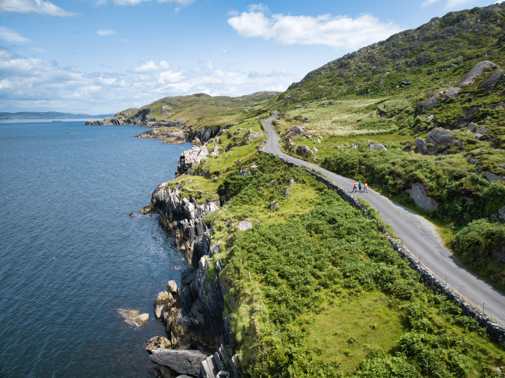
The Beara Peninsula beckons, less celebrated than the Ring of Kerry, but in my book even lovelier. It’s wilder, emptier, and feels closer to the old Ireland, the one of small farms and big weather.
At the tip of the peninsula, Dursey Island is reached by Ireland’s only cable car, the elderly contraption that dangles nonchalantly over the Atlantic. It has been replaced by a more modern one, but it still carries sheep as well as human cargo. There’s no first class. It’s all steerage.
Border crossing without the fuss
CROSSING from Kerry into Cork, Bantry Bay is a glittering expanse of water. The old market town has a handsome square with a top story attached. It was here in 1796 that Theobald Wolfe Tone and his French allies almost changed Irish history. But the wind turned against them, as it so often does on the west coast, and the rebellion never landed. Otherwise you’d probably be reading this column in French today, or even better, in Irish.
A short drive south brings you to Glengarriff, a perfect base for exploring Garinish Island, a subtropical garden conjured out of rock and sea spray. Palm trees grow where you’d expect heather, and seals bark from the harbour as though applauding the absurdity of it all.
West Cork: eccentric, independent, irresistible
ONCE you reach West Cork proper, something changes. The accent softens, the pace drops another gear, and a sense of cheerful independence prevails. Skibbereen, Clonakilty, Schull, Ballydehob — each town could support its own novel. Skibbereen was once known as the “cradle of the Famine”, yet today it’s a lively hub with artisan bakeries and jazz festivals. Clonakilty, home of Michael Collins and of the black pudding, is as close to bohemian as rural Ireland gets.
At a café in Ballydehob, a man told me he’d moved there from Dublin “for the weather.” I raised an eyebrow. “It rains everywhere,” he said, “but at least here you can see it coming.”
The road south to Baltimore curves between hedgerows and glimpses of sea. From here ferries head to Cape Clear — or Oileán Chléire as its 130 or so inhabitants call it (see panel).
Diaspora roots on the road
FOR the Irish abroad, the Wild Atlantic Way has become a sort of secular Camino. Every year thousands of Irish-Americans, London-Irish and second-generation wanderers trace the coastline, perhaps looking for the house their grandparents left behind, or just making a pilgrimage to find something intangible, something totally Irish.
Eventually, all Wild Atlantic wanderings in this corner of Ireland lead to Mizen Head, the dramatic tip of the peninsula and the official southern end of the route. There’s a footbridge suspended over a gorge where the ocean thunders far below, and a restored signal station that once kept watch for transatlantic liners still stands guard.
Stand there on a clear day and you can almost sense America — not see it, but feel its pull across the horizon. Many an emigrant must have paused somewhere along this shore, taking one last look back before heading west.
For more details visit ireland.com
Gracious living on Valentia Island
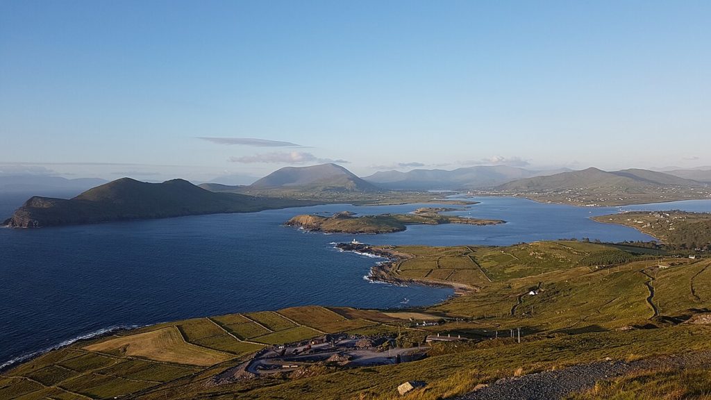 Valentia Island
IN CONTRAST to the monastic living arrangements on Skellig Michael, on Valentia Island there’s a lot of gracious living – at times it almost seems more like Dalkey-on-the-Atlantic, and craic levels reach limits which must be dangerously close to exceeding those laid down by the Geneva Convention. Rightly do they say that pagan abandon allied to a Christian soul lie at the roots of Irish culture.
About 700 souls live on this green morsel of land lying half a mile off the coast of the Iveragh Peninsula. Idyllic it sounds, if somewhat at the end of the line. Once you get to Valentia, there’s only a few yards of the Old World left.
It’s only seven miles by two, but somehow seems much larger, packing an inconceivable number of historical sites, curios and views into one small place.
Valentia is a well-populated island, so every scrap of land has been utilised. Mostly rolling farmland, the fields are divided by slate walls — the same slate that has been used to roof the House of Commons in London. The island is the first part of Europe that the Gulf Stream comes into contact with, and certainly the climate seems tame and the vegetation abundant – a surfeit of palm trees sometimes seems incongruous when it’s a fine soft day absolutely bucketing down.
Valentia Island Heritage Centre and Museum
Common sense is what tells us that the Earth is flat.
But of course we know the world isn’t flat. Fortunately for us wanderers, early explorers and astronomers didn’t go with that gut feeling and worked out long ago that if you sail beyond the Blasket Islands you don’t fall off the edge of the world. The Onion headline “Flat Earth Society ship feared missing” evokes humour not tragedy, as it once might.
The early pioneers in the field of telecommunications likewise didn’t believe in common sense, and in an engineering feat which conquered almost unbelievable odds the first transatlantic cable became fully functional in 1866. For many years after that, Valentia had better communications with New York than with Dublin. You can find out more about the men who wired up Ireland at the old schoolhouse in Glenleam, which now serves as the Valentia Island Heritage Centre and Museum.
Common sense also dictates that Tír na nÓg, the Land of Eternal Youth, doesn’t exist. But Valentia people know it does. Because this part of Kerry is where the legends of the Fianna are set. Their leader Finn Mac Cumhaill would gallop out to sea, sometimes riding on the magical wave Tonn Toime, to visit those other fugitives from Irish mythology, Oisín and Niamh.
And don’t even start me on some of the world’s oldest known footprints — real ones, not mythical. The 385-million-year-old trackways on Valentia Island, Co. Kerry, were left by one of the first creatures to venture onto land. An early four-limbed pioneer hauled itself onshore in Kerry, and crossed what would one day be Ireland.
For more details ireland.com
Cape Clear
The 45-minute ferry ride from the small port of Baltimore to Cape Clear can be across angry seas, and there's always a taste of salt in the air.
"There's a turmoil of converging currents right here,” our skipper, Ciarán, said, pushing a few buttons on his SatNav. "Sounds like my stomach," I quipped, as our boat hit another deep trough. "It stirs things up," Ciarán mused. "Things that fish eat — and where there's fish, you'll always see the odd whale or shark. Oh, and a dolphin or two."
I swallowed hard and squinted at the heaving, sullen sea. Ireland lies astern and Clear Island is somewhere ahead, but both places have been snuffed out by mist and spray. No wonder this was at one time a centre of excellence for pirates, from the 1600s onwards.
Cape Clear Island lies southwest of County Cork, the most southerly inhabited part of Ireland. The south of the island is the most isolated — and when the inhabitants of such a place describe somewhere as isolated, you can take it as fact. Sit on this headland long enough and you will see whales, dolphins and the odd basking shark.
Historically, the most significant site on the island is a short walk away from the North Harbour – St Ciarán's Church.
A short walk from the church, up a hilly track, is the old lighthouse tower and coastguard station. From here you get an affecting, evocative view of the Atlantic — and Fastnet Rock. Known as "Ireland's Teardrop", this was the last part of Ireland most emigrants ever saw. You can’t look at the scene and not think about the thousands who made that journey.
As evening drew on I watched as the Fastnet Lighthouse began flashing across the dark waters. I was lost in thought.
But thoughts eventually returned to more mundane matters — mainly about where to get dinner. Nowhere better than Ciarán Danny Mike's Bar. Fish and Guinness took the starring role, naturally enough. A session soon developed with fiddle, accordion, tin whistle and bodhrán. It was a long night.
Next day (although not too early) it was time to head out towards the bird observatory at North Harbour. This internationally important institution has complete records going back to 1959. There's plenty to observe: the bay is alive with guillemots, cormorants, auks and storm petrels. Rare passage migrants have also been spotted here over the years, including, once, a Baltimore oriole eponymously heading for Baltimore, West Cork. As you're walking round the island look out for choughs — basically crows with bright red beaks.
You’ll also see Arctic skuas (in Irish as méirliún Artach). Evolution has deemed that the way these birds survive is by chasing gulls through the air till they vomit up their food, which they then promptly scoff. This is as baroque a method for sourcing your food as you could come up with. Fortunately, most humans have taken a different evolutionary approach to feeding.
The island, like most of Ireland's western seaboard, features many historic ruins including several early Christian monuments. The most impressive of the old castles is Dún an Oir (the Fort of Gold), a former O'Driscoll redoubt, standing on a narrow ledge which becomes an island at high tide. To get a good handle on the history of the area, including the ancient Gaelic chieftains, pop into the splendid little museum at North Harbour, the Cape Clear Island Museum.
Because Cape Clear is about the first place in Europe to be washed by the Gulf Stream, the climate is mild. Sea pinks cling to the rocks, and honeysuckle clambers wherever it can. The hills are covered with heather and coarse grass, and the going is quite easy to the highest point on the island, Cnoc Caraintín, some 522 feet above the Atlantic. From here you get epic views of Mizen Head, Fastnet Rock and nearby Sherkin Island.
Cape Clear is three miles square, hilly, rugged, and quite beautiful. If you've any interest in the flora and fauna of south-western Ireland, or its traditions and language, it's an essential destination.
Islands are always fun; a little sea and isolation give places a mystique in inverse proportion to their size, and Cape Clear eminently qualifies on all those scores. To quote Ethel Mannin, writing in 1947:
"It was a grey afternoon, with a spatter of rain in the air, but the colours were pure Paul Henry — the misty blues of distant hills, the golden brown of the mountain, the black and brown of the seaweedy strip of shore at low tide, the ice green of the water where the wind whipped it, and the whole of it held in a light to be found nowhere else in the world."
St Ciaran of Cape Clear
HISTORICALLY, the most significant site on Cape Clear is a short walk away from the North Harbour, St Ciarán's Church. This is traditionally believed to be where Mass was first celebrated in Ireland, sometime in the 4th century. St Ciarán, who was born on Cape Clear, may have been the first to bring Christianity to Ireland, never mind St Patrick.
It is sometimes said that Christianity first came to Ireland via Spain or France, but the bitter truth is that it probably came across the sea from Britain. Having said that, it's known that Ciarán himself went straight to HQ, in other words Rome, where he was consecrated as the first bishop of Ireland. It's possible he may even have bumped into Patrick in Europe and persuaded him to return to Ireland. Whatever the exact details, St Ciarán's feast day is March 5, and is marked in some style on the island with a holiday and celebrations.
Throughout the year Cape Clear has various festivals featuring everything from painting to storytelling.
See More: Ireland, Travel, Wild Atlantic Way
